
By Julia Davis
After devastating LA wildfires, CEE’s RAPID Facility collects key data to study long-term health, environmental and recovery impacts.
.jpg)
An aerial view shows clusters of homes that survived while neighboring structures were destroyed by the wildfires. Photos courtesy of RAPID.
When massive wildfires tore through the Los Angeles area earlier this year, they left behind more than charred homes and scorched hillsides. They also raised pressing questions about public health, environmental safety and how communities recover after such devastation. To help answer those questions, the UW’s RAPID Facility quickly mobilized.
“The Los Angeles fires are among the most significant U.S. disasters of the past decade,” says Joe Wartman, director of the RAPID Facility and CEE professor. “We immediately recognized this as an important event and began making plans for a field deployment.”
Over the course of four visits to the region, RAPID collected high-resolution imagery, 3D lidar scans, and environmental data, including air and water quality measurements. Much of this was captured using RAPID’s new hyperspectral imaging system, which can detect post-fire toxins, such as ash and contaminated soil, not visible to the naked eye.
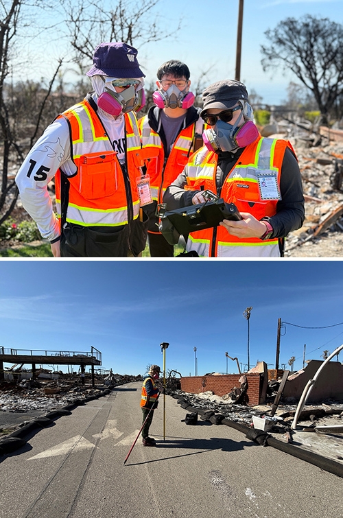
Top photo: RAPID researchers wear protective equipment while collecting data in areas with lingering toxins from debris. Bottom photo: A RAPID researcher surveys structural damage in a fire-ravaged area to help document baseline conditions for long-term recovery analysis.
Wartman notes that the team’s initial observations revealed more than structural damage. “After our first visit, we realized that beyond damage to the built and natural environment, there were significant health impacts,” he says.
A key focus has been gathering baseline data — detailed documentation of conditions in the immediate aftermath of the fire. This time-sensitive information allows researchers to track how the environment and communities change over the coming months and years.
“Baseline data serves as the critical starting point for any long-term longitudinal studies,” Wartman explains. “Without it, we don't know what the on-ground conditions were immediately after the fire, making it difficult to assess changes during the recovery period, which will inevitably span many years.”
The wildfire’s impact on densely populated neighborhoods also brought unique challenges. Because of concerns about lingering toxins in debris, RAPID implemented specialized health and safety protocols for team members during fieldwork.
One unexpected observation stood out: clusters of surviving homes surrounded by destruction. Researchers hope the data will help uncover why some structures remained intact, whether due to construction materials, vegetation or local terrain.
The effort is supported by a multi-institutional research team led by UCLA, with collaborators from Oregon State University, the University at Buffalo and the Public Health Extreme Events Reconnaissance (PHEER) organization. The team includes experts across engineering, environmental science and public health, all working together to better understand the impacts of wildfires and inform future disaster resilience strategies.
“Fire is quickly becoming the most costly environmental hazard in the U.S. and globally,” says Wartman. “Unless we understand the factors that led to the initiation and spread of this fire, we can't develop mitigation approaches to help minimize such events in the future.”
Originally published June 3, 2025