
By Julia Davis
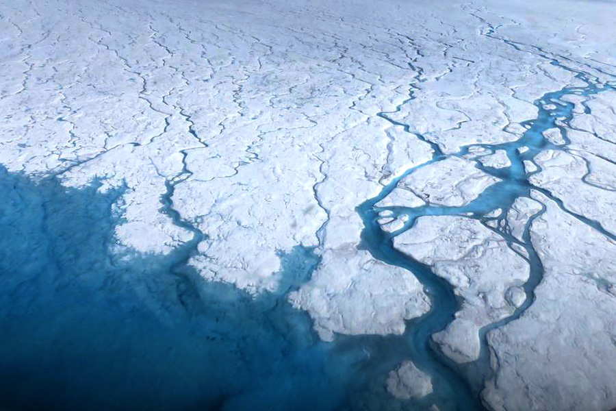
Streams and rivers flow over the Greenland ice sheet during spring and summer. Photos courtesy of NASA’s Goddard Space Flight Center / Maria-José Viñas

David Shean
NASA selected the Earth Dynamics Geodetic Explorer (EDGE) mission, with CEE Associate Professor David Shean serving as a co-investigator on the mission’s science team.
The selection advances EDGE into the next phase of development under NASA’s Earth System Explorers Program, which supports principal investigator-led missions based on priorities identified by the scientific community. Led by Helen Amanda Fricker of the Scripps Institution of Oceanography at the University of California San Diego, EDGE will use laser measurements to create high-resolution, 3D maps of the Earth’s surface and track how it changes over time. The EDGE team also includes UW Applied Physics Laboratory researchers Benjamin Smith, a senior principal physicist, and Tyler Sutterley, a senior research scientist.
A sharper view of a changing planet
EDGE will observe the 3D structure of terrestrial ecosystems, such as how tall and dense forests are, and the surface topography of ice sheets, glaciers and sea ice. It builds on measurements from NASA’s ICESat-2 and GEDI missions, which also use lasers to measure Earth’s surface. Unlike ICESat-2, which uses six laser beams, EDGE will use 40, dramatically increasing how much of Earth’s surface it can measure in each pass.
Instead of a sparse set of tracks, EDGE is designed to collect tightly spaced swaths of measurements that form a 3D “image” of the surface — making it possible to turn repeated passes into detailed maps of change.
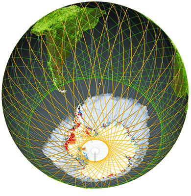
EDGE orbit (orange tracks) extends to the polar regions allowing for dense mapping around the edges of ice sheets and sea ice. Photo courtesy of EDGE
What EDGE makes possible
Shean says the jump in capability is what makes EDGE unique.
“We’re going to be able to see things in new detail with remarkable precision and accuracy,” he says. “And that means we can measure very subtle changes in the Earth’s surface due to processes like ice melt, snow accumulation, landslide motion and volcanic deformation — all of these things that are happening around the world every day.”
Shean emphasizes that those measurements will extend far beyond the mission’s core science goals.
“These precise surface elevation change measurements are essential for so many pressing scientific and engineering applications,” he says in a UW News story. “The EDGE data will have implications for sea level rise, natural hazards monitoring, water resource and forest management, and wildfire response.”
Shean’s role on the EDGE team includes developing data-fusion approaches to combine EDGE’s precise elevation measurements with information from other satellite data, a task that will require managing unusually large data volumes. Tools like SlideRule Earth, a UW/NASA Goddard project for cloud-based data processing and analysis, can extract meaningful information from huge satellite datasets in seconds, making it easier for researchers to use EDGE data well beyond the mission’s primary two-year window.
"I think this mission is going to be an important milestone in terms of what we can do to understand what’s happening on our planet...The Earth’s surface is constantly changing, and we need missions like EDGE to understand what’s happening and why."
“The real power is being able to tie together two decades of very precise measurements from past NASA missions. The EDGE measurements will be a new benchmark allowing us to see changes in the past and changes in the next few decades,” Shean says.
Researchers will be able to line up EDGE measurements with older records and future observations to track change over time — separating short-term swings, like seasonal snow or vegetation cycles, from longer-term shifts like ice sheets’ net ice loss over years and decades.
“I think this mission is going to be an important milestone in terms of what we can do to understand what’s happening on our planet,” Shean says. “That priority isn’t going to go away; the Earth’s surface is constantly changing, and we need missions like EDGE to understand what’s happening and why.”
From selection to launch
NASA’s selection moves EDGE into the next phase of development ahead of an agency review in 2027 to finalize the mission’s design, schedule and budget. NASA estimates the total mission cost at no more than $355 million, not including launch, with a launch date no earlier than 2030.
Related story

EDGE mission named NASA finalist
In May 2024, NASA named EDGE as a finalist mission concept. Read how UW researchers, including CEE’s David Shean, helped shape the proposal.
EDGE is one of two Earth System Explorers missions selected by NASA. The other is STRIVE, led by UW atmospheric scientist Lyatt Jaeglé, which will measure the atmosphere to improve understanding of ozone, air quality and longer-range weather forecasting.
Shean emphasized that EDGE reflects years of proposal and design work, including rigorous internal and external reviews that stress-tested the mission plan for technical, budget and schedule risks.
EDGE was designed around two key measurements highlighted in NASA’s Earth System Explorers Program: mapping the 3D structure of ecosystems, including forests, and measuring small but significant height changes across ice sheets, glaciers and sea ice. While many mission concepts tend to focus on one priority, EDGE combined both in one mission, strengthening the team’s case to address a broader set of Earth science questions. Those ice measurements help scientists track how much ice is being lost to melting versus gained by snowfall — information that’s critical for understanding sea level rise.
He credited the leadership and engineering teams behind the mission, describing the past 4+ years as a sustained push to prove the mission can meet ambitious science requirements within NASA’s cost cap and technical constraints.
For Shean, the selection is also the culmination of a long-term interest in Earth observation satellite missions and the beginning of a new phase of his career.
“I got involved in research in the first place because I wanted to be part of these satellite missions,” he says.
With EDGE selected, Shean says the hard work shifts from proposal mode to building the hardware and data processing pipelines needed to support rapid scientific use once the satellite is in orbit.
He also sees the mission as a training opportunity for students at the UW, not only to analyze the EDGE data, but to learn firsthand about how large, interdisciplinary NASA satellite missions come together.
“This is a major milestone for the UW, as it formalizes UW leadership and involvement on not one, but two NASA Earth Observation missions,” he says. “I’m excited to bring students onto the EDGE team and train the next generation of UW researchers who will do amazing things with EDGE data in the coming decades.”
Originally published February 20, 2026